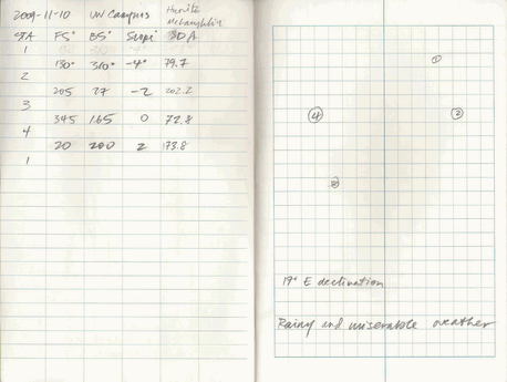
A worked example
A worked example. Here are the field notes. Note that skipping a
line makes it easier to discern which measures are taken between
which stations.
The first step is to transcribe the field notes into Excel or
whatever tabular data manipulation environment you will be using.
Note we have used sta.from and
sta.to in order to keep things straight. raw data
sta.from sta.to fs bs slope sd
1 1 2 130 310 -4 79.7
2 2 3 205 27 -2 202.2
3 3 4 345 165 0 72.8
4 4 1 20 200 2 173.8
The declination of 17° is added to each fs
measurement to create fs.dec. Why is the
declination added? Imagine if you obtained a magnetic
measurement of 0°, that translates to 17° east of true north. Declination correction
sta.from sta.to fs bs slope sd fs.dec
1 1 2 130 310 -4 79.7 147
2 2 3 205 27 -2 202.2 222
3 3 4 345 165 0 72.8 2
4 4 1 20 200 2 173.8 37
Correct
horizontal distance for slope :
HD = SD * cos(slope° * pi / 180)
Note that the differences between slope and horizontal distances
are small because there was not much elevation change over the
surveyed area. Horizontal distance
sta.from sta.to fs bs slope sd fs.dec hd
1 1 2 130 310 -4 79.7 147 79.50585
2 2 3 205 27 -2 202.2 222 202.07683
3 3 4 345 165 0 72.8 2 72.80000
4 4 1 20 200 2 173.8 37 173.69413
We should also obtain the sum of horizontal distance, which will
be needed in the latitudes and departures corrections: Sum of HD: 528.08
Calculate
interior angles. This is done by using foreshots and backshots.
For example, angle 4-1-2 is calculated:
200 - 130 = 70 Interior Angles
sta.from sta.to fs bs slope sd fs.dec hd ia
1 1 2 130 310 -4 79.7 147 79.50585 70
2 2 3 205 27 -2 202.2 222 202.07683 105
3 3 4 345 165 0 72.8 2 72.80000 42
4 4 1 20 200 2 173.8 37 173.69413 145
Looks like we got fairly close with the sum of interior
angles. Sum of interior angles: 362
Correct
the azimuths based on the interior angle error. In this case the
error was +2, and the number of angles was 2. To make the corrected
interior angles sum to 360, it is necessary to subtract 0.5 from
each measured azimuth.
Corrected azimuths
  sta.from sta.to  fs  bs slope    sd fs.dec        hd  ia fs.cor
1        1      2 130 310    -4  79.7    147  79.50585  70  146.5
2        2      3 205  27    -2 202.2    222 202.07683 105  221.5
3        3      4 345 165     0  72.8      2  72.80000  42    1.5
4        4      1  20 200     2 173.8     37 173.69413 145   36.5
To calculate corrected interior angles, add or subtract the
correction factor to each interior angle (not shown, because we
don't need the corrected interior angles for further calculation).
Calculate
latitudes and departures. For example, look at station 2:
latitude = hd * cos(azimuth) = 202.07 * cos(222 * pi / 180)
= 150.17 Latitudes and Departures
sta.from sta.to fs bs slope sd fs.dec hd ia fs.cor lat dep
1 1 2 130 310 -4 79.7 147 79.50585 70 146.5 -66.29881 43.882222
2 2 3 205 27 -2 202.2 222 202.07683 105 221.5 -151.34659 -133.900156
3 3 4 345 165 0 72.8 2 72.80000 42 1.5 72.77505 1.905682
4 4 1 20 200 2 173.8 37 173.69413 145 36.5 139.62521 103.317224
Calculate the sums of latitudes and departures.
Sums of L&D: -5.25 15.2
Under perfect conditions these should sum to 0. Because they
don't, determine
the correction. For example, station 1:
-(-5.25 / 528.08 * 79.51) = 0.79 Latitude and Departure correction factors
sta.from sta.to fs bs slope sd fs.dec hd ia fs.cor lat dep lat.cor dep.cor
1 1 2 130 310 -4 79.7 147 79.50585 70 146.5 -66.29881 43.882222 0.7896932 -2.289221
2 2 3 205 27 -2 202.2 222 202.07683 105 221.5 -151.34659 -133.900156 2.0071314 -5.818420
3 3 4 345 165 0 72.8 2 72.80000 42 1.5 72.77505 1.905682 0.7230872 -2.096138
4 4 1 20 200 2 173.8 37 173.69413 145 36.5 139.62521 103.317224 1.7252197 -5.001194
Balance
the latitudes and departures by adding the correction factors to
the originally calculated latitudes and departures. For example,
station 1:
-66.3 + 0.8 = -65.5 Balanced Latitude and Departure
sta.from sta.to fs bs slope sd fs.dec hd ia fs.cor lat dep lat.cor dep.cor lat.bal dep.bal
1 1 2 130 310 -4 79.7 147 79.50585 70 146.5 -66.29881 43.882222 0.7896932 -2.289221 -65.50911 41.5930012
2 2 3 205 27 -2 202.2 222 202.07683 105 221.5 -151.34659 -133.900156 2.0071314 -5.818420 -149.33946 -139.7185753
3 3 4 345 165 0 72.8 2 72.80000 42 1.5 72.77505 1.905682 0.7230872 -2.096138 73.49814 -0.1904563
4 4 1 20 200 2 173.8 37 173.69413 145 36.5 139.62521 103.317224 1.7252197 -5.001194 141.35043 98.3160304 Sums of balanced lat & dep: 0 0
Calculate
X and Y coordinates by starting at a known point (station1 in
this example), and then sequentially adding the latitudes and
departures of subsequent points.
X and Y
  sta.from sta.to  fs  bs slope    sd fs.dec        hd  ia fs.cor        lat         dep   lat.cor   dep.cor    lat.bal      dep.bal       x        y
1        1      2 130 310    -4  79.7    147  79.50585  70  146.5  -66.29881   43.882222 0.7896932 -2.289221  -65.50911   41.5930012 1277180 241854.7
2        2      3 205  27    -2 202.2    222 202.07683 105  221.5 -151.34659 -133.900156 2.0071314 -5.818420 -149.33946 -139.7185753 1277221 241789.2
3        3      4 345 165     0  72.8      2  72.80000  42    1.5   72.77505    1.905682 0.7230872 -2.096138   73.49814   -0.1904563 1277082 241639.9
4        4      1  20 200     2 173.8     37 173.69413 145   36.5  139.62521  103.317224 1.7252197 -5.001194  141.35043   98.3160304 1277082 241713.3
It is possible to double-check the calculated X and Y coordinates
by adding the latitudes and departures for the last station. They
should result in the coordinates for the first station:
1277082 + 98 = 1277180
241713.3 + 141.3 = 241854.7
Another check can be done by calculating the distances between
stations (using the Pythagorean theorem) and comparing them with the
measured distances. For example, line 3-4 (note the XY coordinates
shown in the table are displayed in a truncated form):
sqrt((1277081.77 - 1277081.58)^2 + (241639.85 -
241713.35)^2) = 73.5 Distance
sta.from sta.to fs bs slope sd fs.dec hd ia fs.cor lat dep lat.cor dep.cor lat.bal dep.bal x y dist
1 1 2 130 310 -4 79.7 147 79.50585 70 146.5 -66.29881 43.882222 0.7896932 -2.289221 -65.50911 41.5930012 1277180 241854.7 77.59782
2 2 3 205 27 -2 202.2 222 202.07683 105 221.5 -151.34659 -133.900156 2.0071314 -5.818420 -149.33946 -139.7185753 1277221 241789.2 204.50808
3 3 4 345 165 0 72.8 2 72.80000 42 1.5 72.77505 1.905682 0.7230872 -2.096138 73.49814 -0.1904563 1277082 241639.9 73.49839
4 4 1 20 200 2 173.8 37 173.69413 145 36.5 139.62521 103.317224 1.7252197 -5.001194 141.35043 98.3160304 1277082 241713.3 172.18010
The last calculations are:
- Area,
which can be calculated from the XY coordinates.
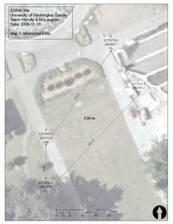
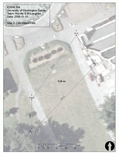
Area: 11308.6 ft2 = 0.26 ac
EOC = sqrt((-5.25 ft)2 + (15.2 ft)2)
= 16 ft
Finally, a few maps can be made using ArcGIS (click for
full-sized versions):
source
code | 

